

Notification from Aqua Geo Frameworks, LLC
11/13/2024
Note to Local Authorities: In the public interest and in accordance with FAA regulations, the company Aqua Geo Frameworks, LLC is announcing this low-level airborne project. Your assistance informing the local communities is appreciated.
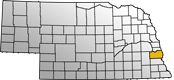
Plattsmouth, NE - Starting around November 15 and lasting up to a week, a helicopter towing a large hoop from a cable will begin making low-level flights over the area near Plattsmouth as part of a geological mapping study.
The helicopter will fly along pre-planned flight paths relatively low to the ground at 100-200 feet above the surface. A sensor that resembles a large hula-hoop will be towed beneath the helicopter to measure tiny electromagnetic signals that can be used to map features below Earth's surface. The helicopter will not focus on individual properties, as the survey only gathers data from below the surface.
The Aqua Geo Frameworks, LLC. (AGF) study will be conducted by the specialty airborne geophysical survey company SkyTEM ApS, under a AGF contract. The helicopter will be operated by experienced pilots from Livewire Aviation who are specially trained for the low-level flying required for geophysical surveys. The company works with the FAA to ensure flights are safe and in accordance with U.S. law. Surveys do not occur directly above populated areas.
AGF-led studies have recently used this type of aerial survey to inform groundwater efforts around the country, including Nebraska, Iowa, Missouri, North Dakota, Colorado, Wyoming and California. By using cutting-edge airborne geophysical technology, AGF scientists efficiently obtain critical information about groundwater resources over large areas, without the need for intensive ground-based work.